
How To Find Your Property On FEMA’s Flood Insurance Rate Maps

What are FEMA flood maps?
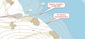
FEMA’s Flood Insurance Rate Maps (FIRMs) or just Flood Maps are provided after a flood risk assessment has been completed or updated for a community.  This study is known as a Flood Insurance Study.  The FIRM gives you the Base Flood Elevations (BFEs) and insurance risk zones in addition to floodplain boundaries.  The FIRM may also show a delineation of the regulatory floodway.

Once the “insurance risk zone”  (commonly referred to as the flood zone) is determined, actuarial rates, based on these risk zones, are then applied for newly constructed, substantially approved, and substantially damaged buildings.  FEMA uses these rates to determine the insurance rate you will pay for flood insurance

FEMA’s Digital Flood Maps

FEMA discontinued the production and distribution of paper flood maps in 2009 as part of its Digital Vision Initiative. This affected all the Flood Maps, boundary information, and study reports. However, clients can still view the products for free through their website or buy them in digital format.

To view these flood maps online, go to FEMA’s Map Service Center and key in your address (hi-lited area shown here) search for your home.  This will prompt you to then select the map that covers your area.  The Flood Maps are somewhat cumbersome to use online. It is best to go through the tutorial on the bottom right of the address search page for an easier and more effective use of the GIS map.

author avatar
Surveyor

More Posts

Land surveyor reviewing an old property survey at a residential property with recent improvements
boundary surveying
Surveyor

5 Signs It’s Time to Update an Old Property Survey 

A property survey doesn’t come with an expiration date stamped on it. But that doesn’t mean it stays accurate forever. Land changes. Records get updated. Weather reshapes the ground. If your survey is more than a few years old, it may no longer reflect what’s actually happening on your property.

Read More »
Surveyors conducting land surveys on an undeveloped property before development planning
land surveying
Surveyor

Understanding Land Surveys Through Real-World Projects

You’re ready to buy land and build. But wait. One step comes first. Land surveys tell you what you actually have. Not what you think. What’s really there? A survey measures your property lines. It checks for utilities. It shows the ground shape. It finds easements. For Michigan developers, this

Read More »
Aerial view of a planned land subdivision showing divided lots and open land near a residential area
civil engineering
Surveyor

How Much Does It Cost to Subdivide Land?

If you have been searching for how much does it cost to subdivide land, you are not alone. In Grand Rapids, most subdivision projects cost between $8,000 and $75,000. The final number depends on your lot size, how many new parcels you need, and how close your property is to

Read More »
An engineer reviewing site plans with a client before a commercial project begins
civil engineering
Surveyor

When Should You Hire a Consulting Engineer? 

You find a commercial property in Grand Rapids. The price looks fair. The space feels right. You start thinking about what you want to build or open. That’s where many owners run into trouble. They move forward based on what they think the site can handle. Later, things don’t quite

Read More »